National Oceanic and Atmospheric Administration (NOAA)
Weather Satellite Automatic Picture Transmission (APT)
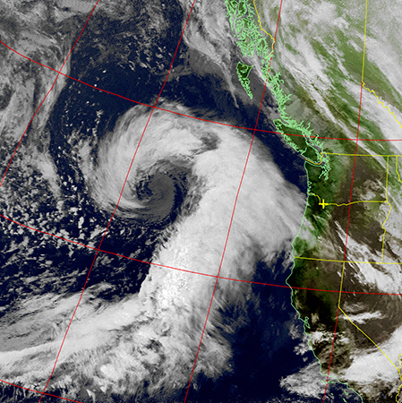
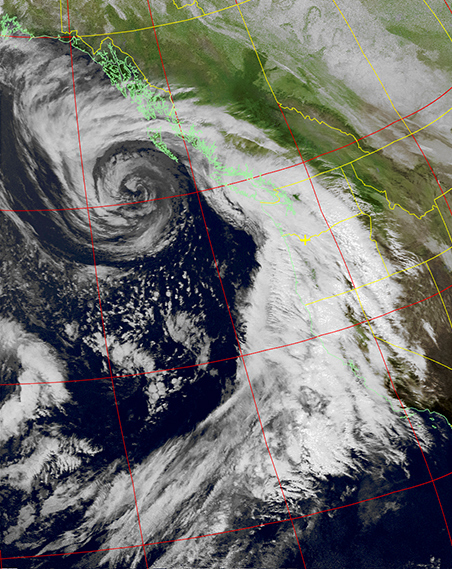
The above
NOAA
weather satellite automatic picture transmission
(APT)
images show a
low pressure area
off the west coast of North America on January 17, 2016.
The coast line is the green line on the right side of the image and the yellow lines are the USA states and Canada provinces.
The red lines are the
latitude and longitude
lines.
The left image was taken at 0151 UTC and the right image was taken about 13 hours later at 1444 UTC. The low pressure area moved northeast during this time.
In the northern hemisphere winds rotate counter-clock wise around the low pressure area as shown by the pattern of the white clouds. A good example of a low pressure moving across the UK is shown in the YouTube video by Met Office.
The
NOAA-15,
NOAA-18 and
NOAA-19
are Polar-orbiting Operational Environmental Satellites
(POES)
in
low Earth orbits (LOE)
that are
Sun-synchronous orbits.
Their APT is continuously transmitted on 136.1 MHz or 136.9125 MHz. The signal is an analog
signal consisting of an amplitude-modulated 2400-Hz subcarrier frequency modulating the RF carrier.
The FM modulation is 30 kHz wide which prevents narrow FM modulation receivers from being used. Based on the SDR spectrum the receiver bandwidth is set to 50 kHz to receive all the sidebands of the modulated signal.
The NOAA-19 APT image resolution is 4-km (2.5-mi).
Two POES observe every part of the Earth at least twice every 12 hours.
POES deliver meteorological data free of charge to users worldwide.
NOAA satellites are responsible for daytime afternoon orbits.
The
NOAA-15 satellite image
and
NOAA-18 satellite image
were received with an
Airspy
software define radio
(SDR) receiver and the image decode was done with
WXtoImg
software.


|
Weather Satellites
Satellite Image Weather Analysis
YouTube Videos
Weather Maps
Weather Satellites Tracking on the Internet
Satellite Tracking Software
APT Decoding Software
Meteorology
Weather Satellite Links
|
© 1998-2016 David Haworth WA9ONY