Sky Charts
Calendar
This function displays various astronomical phenomena for a given time period.
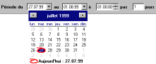
You can select start date, end date, the time when
positions are calculated and number of days between
each calculation.
By default the calculations are from the current
date for five days at 0h UT.
Beware of the calculation time if too many dates are
selected.
Clicking on the table displays the chart for the corresponding date. The program shows a chart centered on the selected object using the entered date and time. If the selected column contains the time for a specific event such as the planet rise or the twilight time, this time is used for the chart. There are more functions for the eclipses and the artificial satellites that are described on the corresponding page.
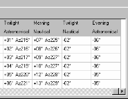
Twilight:
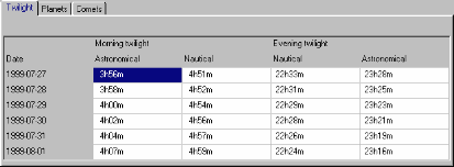
This screen shows the morning and evening twilight time for each date selected.
Nautical twilight is when the Sun is 12 degrees below the horizon - brighter stars are visible.
Astronomical twilight is when the Sun is 18 degrees below the horizon - the sky is dark and all stars are visible.
Planets:
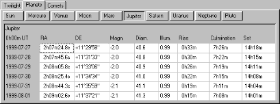
Shows the position, magnitude, apparent diameter, illuminated fraction, rise, culmination and set time, and current azimuth and altitude for the Sun, the Moon and the planets for each date displayed on the table.
Comets:
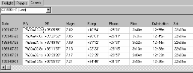
Shows the position, magnitude, Sun elongation, phase, rise, culmination and set time for the selected comet.
The elevation above horizon and azimuth at twilight time are shown to help observe comets near the Sun. This indicates whether the comet is best viewed in the morning or evening.
Solar Eclipses
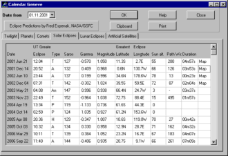
All the information on this page is by
Fred
Espenak, NASA/GSFC.
The list shows the Solar eclipses for the current
century. This shows the date and time of the maxima,
the type of eclipse, the saros number, the gamma
value, the eclipse magnitude, the location of the
eclipse maxima, the altitude of the Sun at this
point, the path width in kilometers, the duration of
the total or annular phase, and the availability of
the detailed map. See a detailed explanation of
these values.
The data from 1800 to 2100 are included with the
basic version. You can download additional data from
the web page.
Clicking the mouse on the list shows the eclipse from
the current observatory location and puts the program
in animation mode.
If you click on the Latitude or Longitude column,
this shows the maxima location on the World map. You
can show the eclipse from this point by closing the
window or selecting another location on the map. The
original location is restored when you exit the
animation mode.
If you click the Map column, the detailed map for
this eclipse will be displayed, if available.
Lunar Eclipses
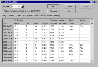
All the information on this page is by
Fred
Espenak, NASA/GSFC.
The list shows the Lunar eclipses for the current
century. This shows the date and time of the maxima,
the type of eclipse, the saros number, the gamma
value, the magnitude of the penumbra and umbra, and
the duration of the partial and total phases. See a detailed explanation of
these values.
The data from 1800 to 2100 are included with the
basic version. additional data can be downloaded from
the web page.
Clicking the mouse on the list shows the eclipse from the current observatory location and puts the program in animation mode.
Artificial Satellites
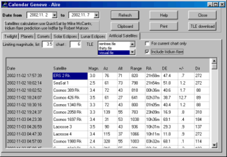
The calculation for artificial satellites uses Mike McCant's QuickSat
program and Robert Matson's Iridflar program. Take the time to read the
documentation for these programs. It is located in the cat\satellites
folder.
First select the date range for the prediction, the limiting magnitude for the list and to plot to the chart, the TLE file to use for the calculation (use the Ctrl or Shift key to select multiple files). Use the two check boxes on the right if you want to limit the search to the satellites that cross the current chart (useful for avoiding a satellite trail on a long exposure photograph) or if you want to include the Iridium flare to the list.
The TLE file for the Iridium flare must be named iridium.tle. If you want to show the satellite path before and after the flare on the chart you must include this file on the list and select a limiting magnitude of at least 8 for the chart.
After clicking OK, the list shows the following
values: the date and time of maximum elevation, the
satellite name, the maximum magnitude, azimuth and
altitude of the maxima, distance in kilometers, right
ascension and declination, estimated error on the
prediction time in minutes or for the flare the
distance and direction to the flare maximum, and the
direction of the satellite movement.
If the magnitude is between brackets this indicates
that the absolute magnitude of the satellite is not
known and the calculated value assumes an absolute
magnitude of 6. The magnitude file "Quicksat.mag" can
be updated from the same web page as the TLE.
Clicking on the list shows the chart of this satellite pass but also any other object brighter than the limiting magnitude in a time range of +/- 6 minutes.
Please update the TLE element files regularly (at least every week)using
the "TLE download" button. The files shipped with the program are examples
only. The action of this button is dependent on having the optional TLE_downloader
program installed.
The default action is to launch your web browser to M. McCant's page and
download the TLE files you want to the cat\satellites folder.
If you install the TLE_downloader program the following window is displayed:
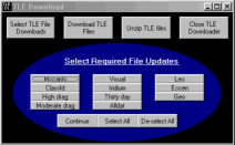
Use to top button in sequence to update the file you want. Use a right
mouse click on this form to get more information.